DR Congo Volcanoes
-
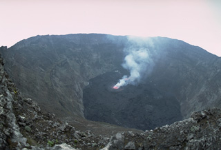
Nyiragongo
-
Nyamulagira
-
Nyamulagira
-
Nyiragongo
-
Nyiragongo
-
Nyamulagira
-

Nyamulagira
-
Nyamulagira
-
Nyamulagira
-
Nyamulagira
-
Nyiragongo
-
Nyamulagira
-
Nyiragongo
-
Karisimbi
-
Nyamulagira
-

Nyamulagira
-
Nyamulagira
-
Nyamulagira
-

Nyiragongo
-

Nyamulagira
DR Congo has 4 Holocene volcanoes. Note that as a scientific organization we provide these listings for informational purposes only, with no international legal or policy implications. Volcanoes will be included on this list if they are within the boundaries of a country, on a shared boundary or area, in a remote territory, or within a maritime Exclusive Economic Zone. Bolded volcanoes have erupted within the past 20 years. Suggestions and data updates are always welcome ().
| Volcano Name | Location | Last Eruption | Primary Volcano Type |
|---|---|---|---|
| Karisimbi | DR Congo-Rwanda border | 8050 BCE | Stratovolcano |
| Nyamulagira | DR Congo | 2024 CE | Shield |
| Nyiragongo | DR Congo | 2023 CE | Stratovolcano |
| Visoke | DR Congo-Rwanda border | 1957 CE | Stratovolcano |
Chronological listing of known Holocene eruptions (confirmed or uncertain) from volcanoes in DR Congo. Bolded eruptions indicate continuing activity.
| Volcano Name | Start Date | Stop Date | Certainty | VEI | Evidence |
|---|---|---|---|---|---|
| Nyamulagira | 2018 Apr 18 | 2024 Apr 19 (continuing) | Confirmed | Observations: Reported | |
| Nyamulagira | 2016 Nov 27 | 2017 May 2 | Confirmed | 0 | Observations: Reported |
| Nyamulagira | 2014 Jun 22 | 2016 May 14 | Confirmed | 0 | Observations: Satellite (infrared) |
| Nyamulagira | 2011 Nov 6 | 2012 Mar 16 (?) | Confirmed | 2 | Observations: Reported |
| Nyamulagira | 2010 Jan 2 | 2010 Jan 29 | Confirmed | 1 | Observations: Reported |
| Nyamulagira | 2006 Nov 27 | 2006 Dec 5 (?) | Confirmed | 2 | Observations: Reported |
| Nyamulagira | 2004 May 8 | 2004 May 28 ± 3 days | Confirmed | 2 | Observations: Reported |
| Nyamulagira | 2002 Jul 25 | 2002 Sep 16 (?) ± 15 days | Confirmed | 2 | Observations: Reported |
| Nyiragongo | 2002 May 17 (?) | 2023 Oct 24 | Confirmed | 2 | Observations: Reported |
| Nyiragongo | 2002 Jan 17 | 2002 Feb 3 (in or after) | Confirmed | 1 | Observations: Reported |
| Nyamulagira | 2001 Feb 6 | 2001 Apr 5 ± 4 days | Confirmed | 2 | Observations: Reported |
| Nyamulagira | 2000 Jan 27 | 2000 Feb 10 (in or after) | Confirmed | 2 | Observations: Reported |
| Nyamulagira | 1998 Oct 17 | 1998 Oct 25 (in or after) | Confirmed | 2 | Observations: Reported |
| Nyamulagira | 1996 Dec 1 | 1996 Dec 5 (in or after) | Confirmed | 3 | Observations: Reported |
| Nyamulagira | 1994 Jul 4 | 1994 Aug 25 (in or after) | Confirmed | 2 | Observations: Reported |
| Nyiragongo | 1994 Jun 23 | 1996 Mar 16 (?) ± 15 days | Confirmed | 1 | Observations: Reported |
| Nyamulagira | 1991 Sep 20 | 1993 Feb 8 | Confirmed | 3 | Observations: Reported |
| Nyamulagira | 1989 Apr 24 | 1989 Aug 15 ± 5 days | Confirmed | 3 | Observations: Reported |
| Nyamulagira | 1987 Dec 30 | 1988 Jan 4 | Confirmed | 1 | Observations: Reported |
| Nyamulagira | 1986 Jul 16 | 1986 Aug 20 | Confirmed | 2 | Observations: Reported |
| Nyamulagira | 1984 Feb 23 | 1984 Mar 14 | Confirmed | 2 | Observations: Reported |
| Nyiragongo | 1982 Jun 21 | 1982 Oct 17 ± 15 days | Confirmed | 1 | Observations: Reported |
| Nyamulagira | 1981 Dec 25 | 1982 Jan 14 | Confirmed | 3 | Observations: Reported |
| Nyamulagira | 1980 Jan 30 | 1980 Feb 24 | Confirmed | 3 | Observations: Reported |
| Nyiragongo | 1977 Jan 10 | 1977 Jan 10 | Confirmed | 1 | Observations: Reported |
| Nyamulagira | 1976 Dec 23 | 1977 Jun 15 ± 5 days | Confirmed | 1 | Observations: Reported |
| Nyamulagira | 1971 Mar 24 | 1971 May 5 ± 4 days | Confirmed | 3 | Observations: Reported |
| Nyamulagira | 1967 Apr 23 | 1967 May 9 | Confirmed | 2 | Observations: Reported |
| Nyamulagira | 1958 Aug 7 | 1958 Nov 21 | Confirmed | 2 | Observations: Reported |
| Nyamulagira | 1957 Dec 28 | Unknown | Confirmed | 0 | Observations: Reported |
| Visoke | 1957 Aug 1 | 1957 Aug 3 | Confirmed | 1 | Observations: Reported |
| Nyamulagira | 1956 Nov 17 | 1956 Nov 18 | Confirmed | 1 | Observations: Reported |
| Nyamulagira | 1954 Feb 21 | 1954 May 28 | Confirmed | 1 | Observations: Reported |
| Nyamulagira | 1951 Nov 16 | 1952 Jan 16 | Confirmed | 2 | Observations: Reported |
| Nyamulagira | 1951 Jul 25 | 1951 Jul 28 | Confirmed | 1 | Observations: Reported |
| Nyamulagira | 1948 Mar 1 | 1948 Jul 15 ± 5 days | Confirmed | 2 | Observations: Reported |
| Nyamulagira | 1938 Jan 28 | 1940 Jun 25 ± 5 days | Confirmed | 1 | Observations: Reported |
| Nyiragongo | 1927 Mar 16 ± 15 days | 1977 Jan 10 | Confirmed | 1 | Observations: Reported |
| Nyamulagira | 1921 | 1938 Jan 17 ± 3 days | Confirmed | 0 | Observations: Reported |
| Nyamulagira | 1920 | Unknown | Confirmed | 0 | Observations: Reported |
| Nyiragongo | 1920 | 1921 | Confirmed | 1 | Observations: Reported |
| Nyiragongo | 1918 | Unknown | Confirmed | 1 | Observations: Reported |
| Nyamulagira | 1912 Dec 3 | 1913 Apr | Confirmed | 3 | Observations: Reported |
| Nyiragongo | 1911 Aug | 1911 Oct | Confirmed | 1 | Observations: Reported |
| Nyamulagira | 1909 May | 1909 May | Confirmed | 1 | Observations: Reported |
| Nyiragongo | [1908 Dec 1 ± 30 days] | [Unknown] | Uncertain | ||
| Nyamulagira | 1908 | Unknown | Confirmed | Observations: Reported | |
| Nyamulagira | 1907 Nov 7 | 1907 Dec 5 | Confirmed | 3 | Observations: Reported |
| Nyamulagira | 1907 Apr | 1907 May | Confirmed | 1 | Observations: Reported |
| Nyamulagira | [1906] | [Unknown] | Uncertain | ||
| Nyiragongo | 1906 | Unknown | Confirmed | 1 | Observations: Reported |
| Nyamulagira | 1905 Jul 22 | 1905 Sep 25 (in or after) | Confirmed | 2 | Observations: Reported |
| Nyiragongo | 1905 | Unknown | Confirmed | 1 | Observations: Reported |
| Nyamulagira | 1904 Apr | 1904 May 16 (?) | Confirmed | 2 | Observations: Reported |
| Nyamulagira | 1902 Apr 22 (?) | Unknown | Confirmed | 0 | Observations: Reported |
| Nyiragongo | 1902 | Unknown | Confirmed | 1 | Observations: Reported |
| Nyiragongo | 1901 | Unknown | Confirmed | 1 | Observations: Reported |
| Nyamulagira | 1901 | Unknown | Confirmed | 2 | Observations: Reported |
| Nyiragongo | 1900 | Unknown | Confirmed | 1 | Observations: Reported |
| Nyamulagira | 1899 Feb | Unknown | Confirmed | 1 | Observations: Reported |
| Nyiragongo | 1899 | Unknown | Confirmed | 1 | Observations: Reported |
| Nyiragongo | 1898 | Unknown | Confirmed | 1 | Observations: Reported |
| Nyamulagira | 1896 | Unknown | Confirmed | 1 | Observations: Reported |
| Nyamulagira | 1894 Jun | Unknown | Confirmed | 2 | Observations: Reported |
| Nyiragongo | 1894 | Unknown | Confirmed | 1 | Observations: Reported |
| Nyiragongo | 1891 (in or before) | Unknown | Confirmed | Unknown | |
| Visoke | 1891 | Unknown | Confirmed | Unknown | |
| Nyiragongo | 1884 | Unknown | Confirmed | 1 | Observations: Reported |
| Nyamulagira | 1882 | Unknown | Confirmed | Observations: Reported | |
| Nyamulagira | 1865 | Unknown | Confirmed | Observations: Reported | |
| Nyamulagira | 1550 ± 100 years | Unknown | Confirmed | Isotopic: 14C (calibrated) | |
| Karisimbi | 8050 BCE (?) | Unknown | Confirmed | Isotopic: K/Ar |
DR Congo has 2 Pleistocene volcanoes. Note that as a scientific organization we provide these listings for informational purposes only, with no international legal or policy implications. Volcanoes will be included on this list if they are within the boundaries of a country, on a shared boundary or area, in a remote territory, or within a maritime Exclusive Economic Zone. Suggestions and data updates are always welcome ().
There are 46 photos available for volcanoes in DR Congo.
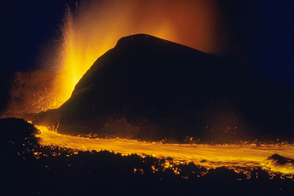
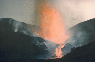
 A new cinder cone, named Gasenyi, ejects fragments of incandescent lava in February 1980. The cone was formed during an eruption that began from a north-flank fissure on January 30. A 2-km-long fissure ejected scoria and ash and fed lava flows. In early February lava fountains were localized at the north end of the fissure and built Gasenyi cinder cone. On the 10th, new vents opened at the south flank of the cone. An explosion the next day destroyed this cone and produced a double-cratered cone.
 Copyrighted photo by Katia and Maurice Krafft, 1980.
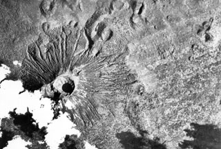
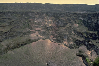
 This aerial photo, with N to the upper left, shows Karisimbi (upper left) and the large 1.2-km-wide Muntango crater (lower right) located S of the summit; the 2-km-wide Branca caldera is located out of view to the right. The recent eruptions from Karisimbi produced a group of vents E of the caldera, which fed lava flows to the east, and the SW-flank lava vents.
Aerial photograph courtesy of Henry Luc Hody (Belgian ambassador).
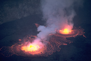
 Lava lake activity seen here on 21 August, began the night of 22-23 June 1994. Lava fountain height reached 30-40 m and the lava lake level was 5-10 m below the height of the 1982 lava lake. Lava lake activity continued until at least September 1995, with accumulation of lava on the crater floor from the end of April to mid-August 1995 causing the crater floor level to rise about 50 m. Observers saw nighttime glow from the crater in November 1995 and February-March 1996.
Photo by Jack Lockwood, 1994 (U.S. Geological Survey).
 This Landsat image shows a portion of the East African Rift north of Lake Kivu (bottom), with N to the upper left. Unvegetated lava flows descend from vents on the summit and flanks, some reaching the shores of Lake Kivu. The forested volcano below and to the right is Nyiragongo, a volcano that frequently contains an active lava lake. Lava flows from flank fissures in 2002 cut across the city of Goma (the light-colored area at the right-hand side of the lake).
NASA Landsat image, 2001 (courtesy of Simon Carn, TOMS Volcanic Emissions Group, Univ. Maryland, Baltimore County).
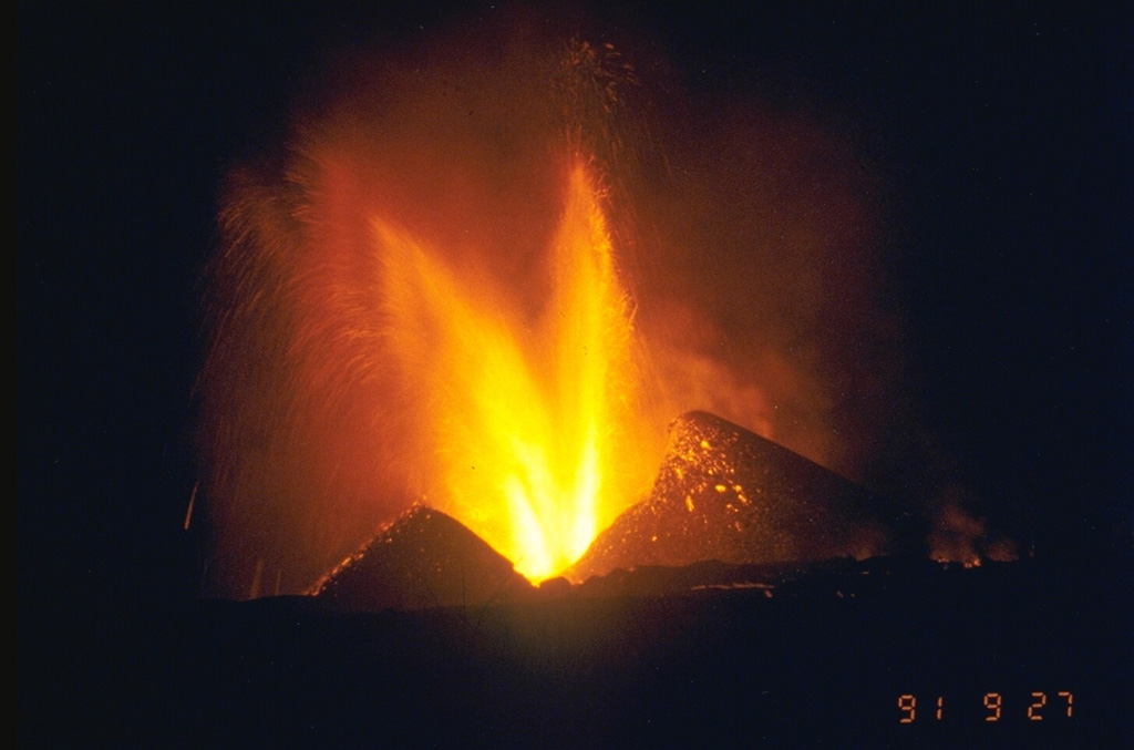
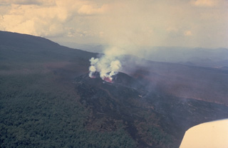
 Lava fountains from the new cone of Mikombe on the lower NE flank of Nyamuragira volcano feed the lava flow in the foreground. This photo was taken from the SE on 29 September, nine days after the start of the eruption. During the first week the new cone grew to a height of 60-70 m. Lava flows had traveled 6-7 km NE by the time of this photo. The eruption continued until February 1993, by which time lava flows had traveled 19 km NE.
Photo by Minoru Kasahara, 1991 (Hokkaido University).
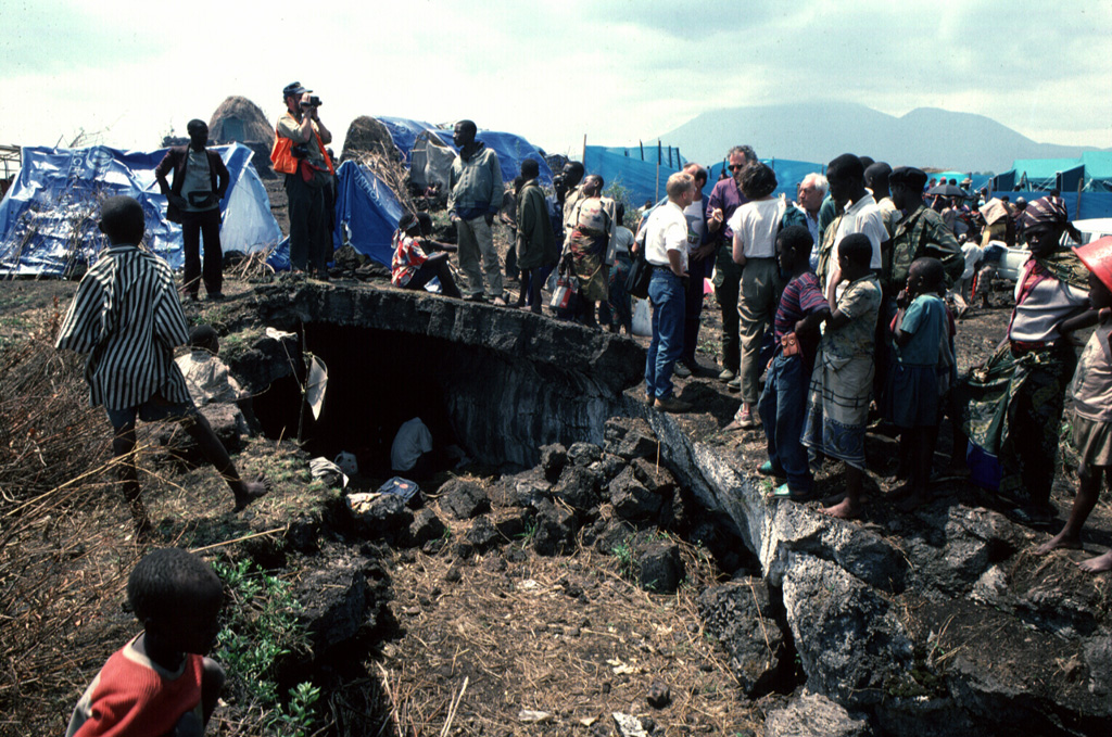
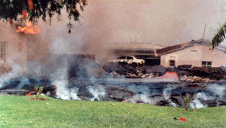
 Major humanitarian crises in eastern Africa played out in areas near Nyiragongo and Nyamuragira volcanoes. This August 1994 photo of the Kitumba refugee camp shows a Rwandan family living in a lava tube on a flow on the SW flank of Nyamuragira volcano with tarps of other shelters in the densely occupied refugee camp beyond. Nyiragongo volcano appears on the right skyline.
Photo by Jack Lockwood, 1994 (U. S. Geological Survey).
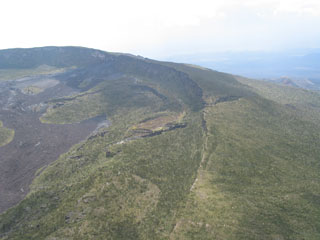
 The summit of Nyamuragira volcano is truncated by 2 x 2.3 km wide caldera whose floor is partially covered by unvegetated historical lava flows. This view from above the SW caldera rim shows a crater on the far side of the caldera (upper left) that was the site of a lava lake, active since at least 1921, which drained in 1938 at the time of a major flank eruption.
 Photo by Simon Carn, 2004 (TOMS Volcanic Emissions Group, University of Maryland, Baltimore County).
 An eruption began on 20 September 1991 on the NE flank, 15 km from the summit. This was the northernmost historical eruption site of Nyamuragira. Lava fountaining from the new Mikombe cone is seen here on 26 September (the 27 September date-time stamp is in Japan Standard Time). Lava flows extended 6-7 km to the NE, cutting the road to Tongo. The eruption became more explosive on 20 November, and by July 1992 had built 26 scoria cones along a NE-trending fissure zone. The eruption continued until 8 February 1993.
Photo by Minoru Kasahara, 1991 (Hokkaido University).
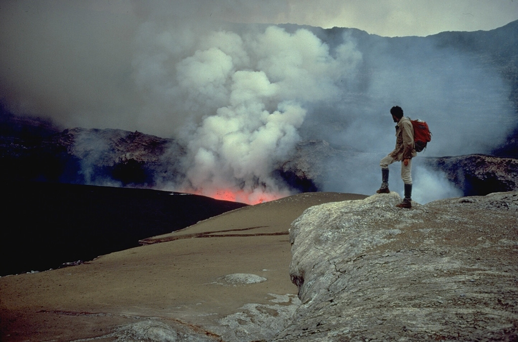
 One of Africa's most notable volcanoes, Nyiragongo contained a lava lake in its deep summit crater that was active for half a century before draining suddenly in 1977. This July 23, 1982 photo from the south crater rim shows a small active lava lake surrounded by black lava flows from the new June 1982 lava lake. Narrow benches halfway up the steep-walled, 1.2-km-wide summit crater mark former lava lake levels.
 Copyrighted photo by Katia and Maurice Krafft, 1982.
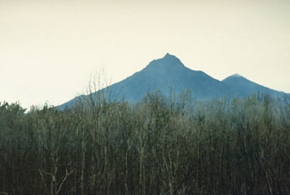
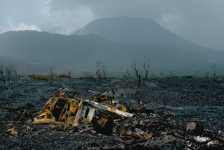 In contrast to the low profile of its neighboring shield volcano, Nyamuragira, 3470-m-high Nyiragongo displays the steep slopes of a stratovolcano. One of Africa's most notable volcanoes, Nyiragongo contained a lava lake in its deep summit crater that was active for half a century before draining suddenly in 1977. This January 1977 photo on the SSE flank shows a vehicle that was overrun by the extremely fluid 1977 lava flows from the draining of the summit lava lake. The older Shaheru stratovolcano appears on the left horizon.
Copyrighted photo by Katia and Maurice Krafft, 1977.
 A lava flow from the April-August 1989 eruption on the east flank of Nyamuragira is seen in this December 1989 view. Low levees bank against the side of the cone. People on the cone on the left horizon provide scale.
Photo by Henry-Luc Hody, 1989 (Belgian ambassador).
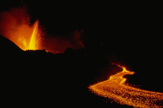
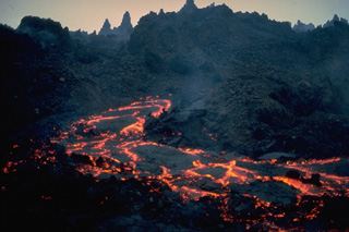 An active incandescent lava channel appears on the spine-covered surface of a rugged aa lava flow at Nyamuragira volcano on January 7, 1982. During this eruption, which began on December 25, 1981, a fissure on the SE flank produced a lava flow that within a few days was 400-m wide. It traveled 26 km through forests on the volcano's NE flanks. This was the longest historical lava flow from Nyamuragira. Substantial tephra emission during the eruption damaged vegetation.
 Copyrighted photo by Katia and Maurice Krafft, 1982.
 A major effusive eruption from vents on the S flank of Nyiragongo volcano in the Democratic Republic of Congo on 17-18 January 2002 produced lava flows that partially inundated the city of Goma, flowing through city streets before entering into Lake Kivu. This photo shows some of the thin and fast lava flows pouring through a narrow chute (behind the car and in line with the left-most opening in the low wall). An incandescent channel is visible at the right, and gas and steam rise from the advancing front of the lava in the foreground.
Photo by Wafula, 2005.
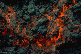 Incandescent lava is visible in the advancing front of an aa lava flow from Nyamuragira on 8 January 1982. The dark irregular areas are already-solidifed masses that can be carried along by the flow and then break off, forming the rough, clinkery surface of aa flows. The December 1981 to January 1982 eruption produced the volcano's longest historical lava flow, which traveled 26 km from its SE-flank vent.
Copyrighted photo by Katia and Maurice Krafft, 1982.
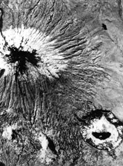
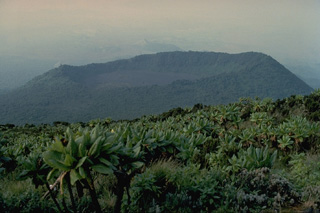
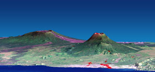
 The Karisimbi volcanic complex (center) includes a symmetrical, peaked summit flanked to the SE by the 2-km-wide Branca caldera, which is filled by viscous lava flows and two craters. The smaller Muntango crater is located S of the summit. A broad lava plain composed of flows erupted within the caldera and along a chain of parasitic cones, extends SW. Eroded Mikeno volcano is at the upper left and Visoke volcano at the upper right of this Landsat image.
NASA Landsat image, 1999 (courtesy of Hawaii Synergy Project, Univ. of Hawaii Institute of Geophysics & Planetology).
 Part of the 6-km-long 10 January 1977 eruptive fissure on the south flank of Nyiragongo is seen in this February 1977 photo. Extremely fluid lava from fissures on the north and south flanks suddenly drained Nyiragongo's summit-crater lava lake. The rapidly moving flows killed 70 people and 800 were left homeless. The dramatic eruption was over in a matter of hours. Conversion of ground water to steam when lava lake terraces collapsed produced a dark gray ash cloud that rose 1 km and caused partial darkness in the city of Goma.
 Copyrighted photo by Katia and Maurice Krafft, 1977.
 Nyiragongo is seen here from the S across Lake Kivu at Peyer Yard in Rwanda. It contained a lava lake in its deep summit crater that was active for half a century before draining suddenly in 1977. In contrast to the low profile of the nearby Nyamuragira shield volcano, Nyiragongo displays the steep slopes of a stratovolcano. About 100 smaller cones are located primarily along radial fissures east of the summit and along a NE-SW zone extending as far as Lake Kivu.
Photo by B. Martinelli, 1994 (courtesy of Jack Lockwood, U.S. Geological Survey).
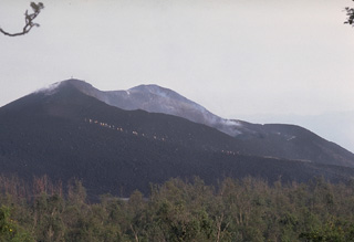
 The summit of the broad Nyamuragira shield volcano is seen here in 1990 from a vent on the upper SE flank. Lava flows from Nyamuragira cover 1,500 km2 of the East African Rift. The summit is truncated by a small 2 x 2.3 km summit caldera. Historical eruptions have occurred within the summit caldera and from the numerous fissures and scoria cones on the flanks.
Photo by Henry-Luc Hody, 1990 (Belgian ambassador).
 Lava fountains rise along the circular margin of a lava lake in the summit crater of Nyiragongo volcano in June 1973. Incandescence is visible through fractures in cooled slabs of lava on the surface of the convecting lava lake. Nyiragongo is renowned for its long-term lava lakes. A half century of continuous lava-lake activity ended suddenly on January 10, 1977, when the lava lake drained rapidly through flank fissures. Prior to draining, the lava lake rose to an elevation of 3300 m, its highest recorded level, only 170-m below the crater rim.
Copyrighted photo by Katia and Maurice Krafft, 1973.
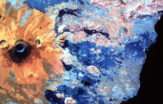 This false-color infrared image shows orange-colored Nyiragongo volcano at the left (north). The crater of the flank cone of Baruta can be seen to the left of the 1-km-wide summit crater. Darker-colored lava flows that mostly erupted from flank fissures extend south (right) to Lake Kivu, and several prominent orange-colored SW-flank scoria cones are visible.
NASA Landsat image, 1994.
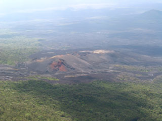
 This February 18, 1980 aerial view shows a newly formed cinder cone on the north flank of Nyamuragira volcano. A lava flow traveling to the north (right) cuts through the forest below the cone. The eruption began from a new north-flank fissure between 1900 and 2000 hrs on January 30. Gasenyi cinder cone was formed and fed lava flows that traveled initially to the east. Another flow traveled down the north flank and reached 13 km to the NE. Activity declined on February 23 and ceased the next morning.
Copyrighted photo by Katia and Maurice Krafft, 1980.
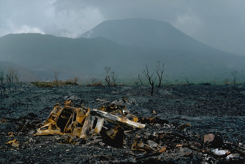
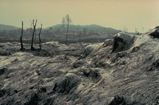
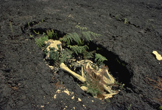 The unusually fluid, high-velocity lava flows produced by the sudden draining of the summit crater lava lake of Nyiragongo volcano in 1977 took their toll on humans and wildlife. The bones of an elephant trapped by the lava flow are contained within the lava-chilled mold of its body. The linear extension at the top left was formed by the animal's trunk. The 1977 lava flows swept down the flanks of the volcano at initial velocities of more than 100 km/hr. The flows killed 70 people and left 800 homeless.
Copyrighted photo by Katia and Maurice Krafft, 1980.
 An eruption began on December 25, 1981 from a 1.5-km-long fissure at 2070 m elevation about 7 km SE of the summit caldera of Nyamuragira. Lava fountains were soon confined to the lower end of the fissure. This January 9, 1982 photo shows lava fountaining at the vent, which is feeding a lava flow that traveled 26 km down the NE flank. This marked the longest historical lava flow of Nyamuragira. Tephra fall destroyed vegetation, resulting in the death of cattle and animals, although no villages were damaged. The eruption ended on January 14.
 Copyrighted photo by Katia and Maurice Krafft, 1982.
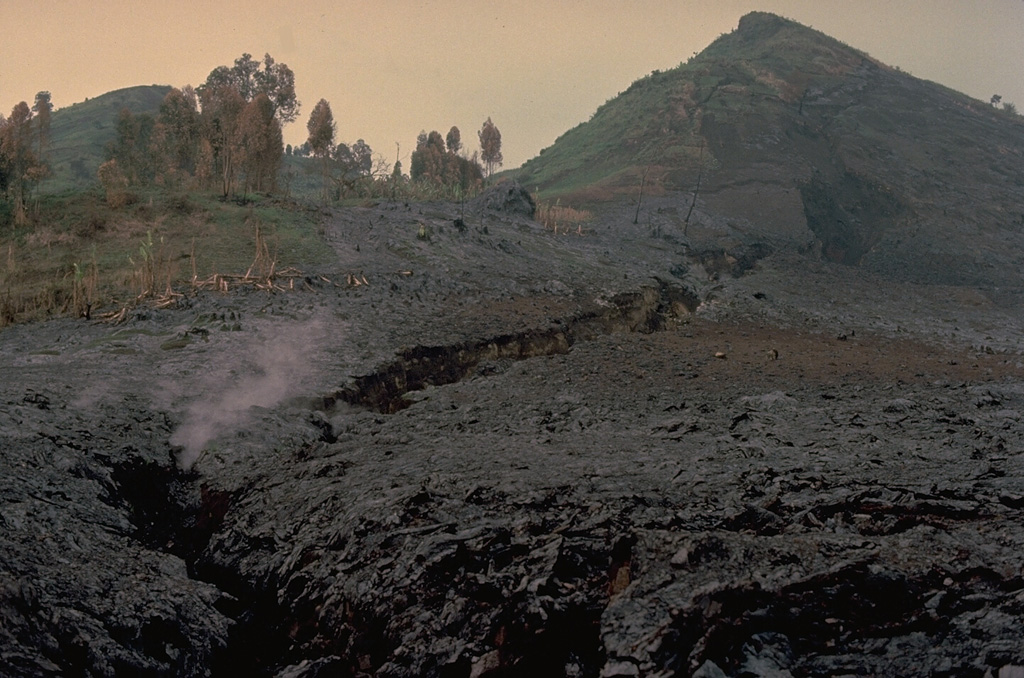
 A fissure (center) cuts the SE caldera rim of Nyamuragira. Several historical eruptions have occurred from both summit and flank vents and have produced lava flows that covered portions of the caldera floor and traveled long distances down the flanks of the volcano.
Photo by Simon Carn, 2004 (TOMS Volcanic Emissions Group, University of Maryland, Baltimore County).
 Steam rises from Kimanura scoria cone, which was formed during an eruption from April to August 1989 on the E flank of Nyamuragira. This December 1989 photo looks N across a black lava flow that had traveled about 20 km down the N flank. The flow diverted around a forested "kipuka" of an older cone (upper right), scorching leaves but not burning the trees. The Kimanura vent was the lowest of three that were active in 1989. A small fissure in the summit caldera and another on the upper SE flank also produced lava flows.
Photo by Henry-Luc Hody, 1989 (Belgian ambassador).
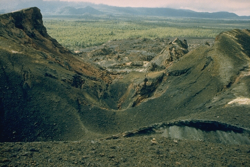
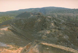
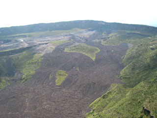 Recent lava flows surround vegetated kipukas on the caldera floor of Nyamuragira volcano in this view from the SW caldera rim. The 2 x 2.3 km wide caldera has walls about 100 m high. A prominent scarp in the middle of the caldera floor at the far left is the rim of a partially buried crater. Historical eruptions have frequently modified the morphology of the caldera floor.
Photo by Simon Carn, 2004 (TOMS Volcanic Emissions Group, University of Maryland, Baltimore County).
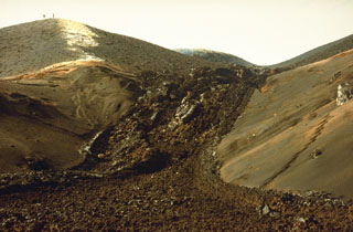
 An eruption from a SSW-flank fissure 16 July to 20 August 1986, produced the Kitazungurwa scoria cone and a lava flow that traveled 19 km down the SW flank. The lava flow partially covered the SW-flank lavas from the 1976-77 Murara eruption. On 18 August the eruption changed from continuous lava fountaining to Strombolian activity. Crops were destroyed by hot ejecta and 150 cattle died from ingestion of ash-covered vegetation.
Photo by D. Meurhaeghe, 1986.
 Visoke volcano is the NE-most of a cluster of large stratovolcanoes at the southern end of the Virunga Range. The volcano contains a 450-m-wide lake in its summit crater (left center). Lobate lava flows descend the flanks of the volcano. A NE-SW-trending fissure zone has produced many scoria cones NE of the volcano (top). An eruption in 1957 formed two small cones on the north flank, 11 km from the summit.
Aerial photograph courtesy of Henry Luc Hody (Belgian ambassador).
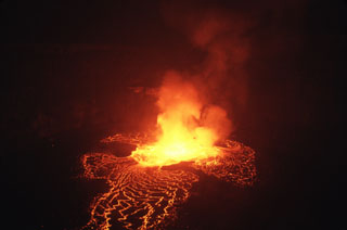
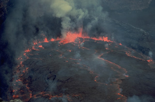
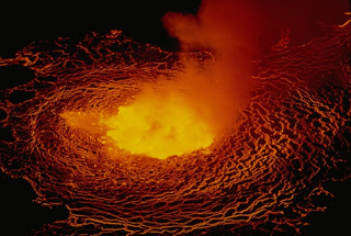
 Incandescent lava flows spill across the crater floor from two fountains in an active lava lake on the crater floor of Nyiragongo on 23 July 1982. The lava lake had reappeared on 21 June for the first time since draining suddenly in 1977, leaving a steep-walled, 800-m-deep crater. Nyiragongo is renowned for its long-term lava lakes. Prior to 1977, a lava lake had persisted in the 1.2-km-wide crater for half a century. By the time of this photo, a month after its return to the crater, the lava lake had risen 300 m. It rose another 100 m by 15 September.
Copyrighted photo by Katia and Maurice Krafft, 1982.
 Lava flows produced by the sudden draining of a lava lake at Nyiragongo were extremely fluid. The thin, rapidly moving lava flows issued from fissures on the north and south flanks, and drained the lava lake in less than an hour. The initial velocity of these unusually fluid lava flows may have been as high as 100 km/hour. They maintained an average velocity of 30 km/hour over a distance of 10 km. The high-velocity flows overran several villages and killed 70 people, leaving 800 homeless.
 Copyrighted photo by Katia and Maurice Krafft, 1977.
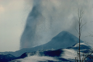
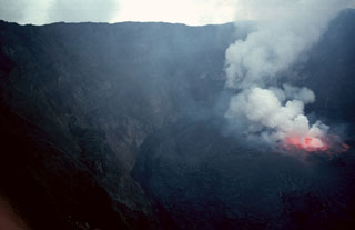 A gas plume rises above lava fountains in a lava lake in the summit crater of Nyiragongo volcano on 20 August 1994. Renewed lava-lake activity began the night of 23-24 June 1994 and continued into the fall of 1996. By August 1995 the surface of the lava lake had risen 50 m.
Photo by Jack Lockwood, 1994 (U.S. Geological Survey).
 Shaheru is one of two large satellitic volcanoes of Nyiragongo. The summit of the south-flank volcano is capped by a roughly 800-m wide crater. A larger stratovolcano, Baruta, was constructed on the northern flank. These two volcanoes give Nyiragongo a double-shouldered profile.
Copyrighted photo by Katia and Maurice Krafft, 1982.
 The 1986 Kitazungurwa fissure is seen in this 1987 photo. The south flank eruption produced a scoria cone and a lava flow that traveled 19 km down the SW flank. The flow traveled to within 2 km of the highway along the north shore of Lake Kivu between Goma and Sake.
Photo by D. Meurhaeghe, 1987.
 A group of African students on a field expedition ascends Gasenyi cinder cone on Nyamuragira on 23 February 1980, shortly before the end of an eruption that began on 30 January. The cinder cone formed at the beginning of February at the northern end of a 2-km-long fissure on the N flank. Lava flows from the cone traveled to the east, NW, and 13 km down the NE flank.
Copyrighted photo by Katia and Maurice Krafft, 1980.
 Smoke rises above a lava fountain in the lava lake at the summit of Nyiragongo volcano in June 1973. Long-term lava lake activity had been occurring since at least 1927. The observer is standing on one of several terraces left by collapse of solidified lava lakes at higher levels. Rapid fluctations of the level of the lava lake have occurred since it was first scientifically documented in the 1950's. The century-long lava lake drained suddenly in 1977.
Copyrighted photo by Katia and Maurice Krafft, 1973.
 Lava lake activity resumed at the summit crater of Nyiragongo on June 21, 1982, the first eruptive activity since the dramatic draining of the lava lake in 1977. Initial phreatic eruptions were followed by lava flow emission from two vents on the inner crater wall that rapidly formed a lava lake. The lava lake level rose 300 m by July 23 and rose another 100 m by September 15. The lava lake was continuing to expand in October, but no activity was seen at the beginning of November.
Copyrighted photo by Katia and Maurice Krafft, 1982.
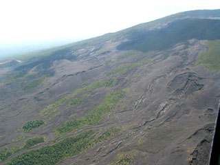 Lava flows from historical eruptions blanket the NW flank of Nyamuragira volcano. Lava flows issuing from radial fissures surround vegetated kipukas. Several major NW-flank eruptions took place in the late-20th century, producing lava flows that reached as far as about 20 km from the summit caldera.
Photo by Simon Carn, 2004 (TOMS Volcanic Emissions Group, University of Maryland, Baltimore County).
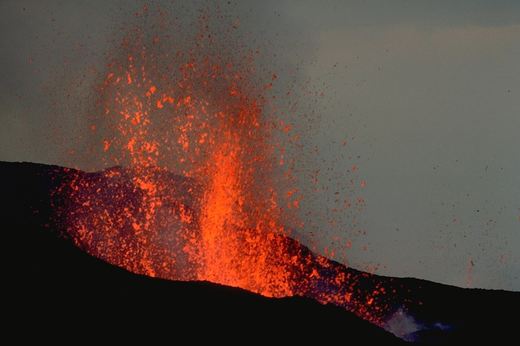
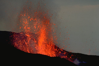
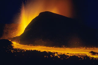
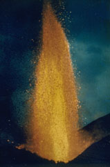
 An explosive eruption from a SE-flank vent of Nyamuragira produces a powerful vertical fountain above the vent at the left. Ash and scoria are blown by winds to the right, where they have accumulated to form the rim of a cinder cone. Hot pyroclastic-fall deposits steam in the foreground of this January 1981 photo. This eruption, which began in December 1981 and ended the following month, produced a large aerosol cloud that was tracked around the globe and produced brilliant sunsets in the following months.
Copyrighted photo by Katia and Maurice Krafft, 1982.
 An evening view from the crater rim of Nyiragongo volcano looks across the floor of the East African Rift at Nyamuragira volcano. The shield volcano is one of Africa's most active volcanoes, producing more than three dozen eruptions since the mid-19th century.
Photo by Simon Carn, 2004 (TOMS Volcanic Emissions Group, University of Maryland, Baltimore County).
 A lava flow from the April-August 1989 eruption around a scoria cone in this 2 December 1989 view. The eruption scorched vegetation on an older cone at the upper left that is now surrounded by the lava. The 1989 lava flow traveled about 20 km to the north.
Photo by Henry-Luc Hody, 1989 (Belgian ambassador).
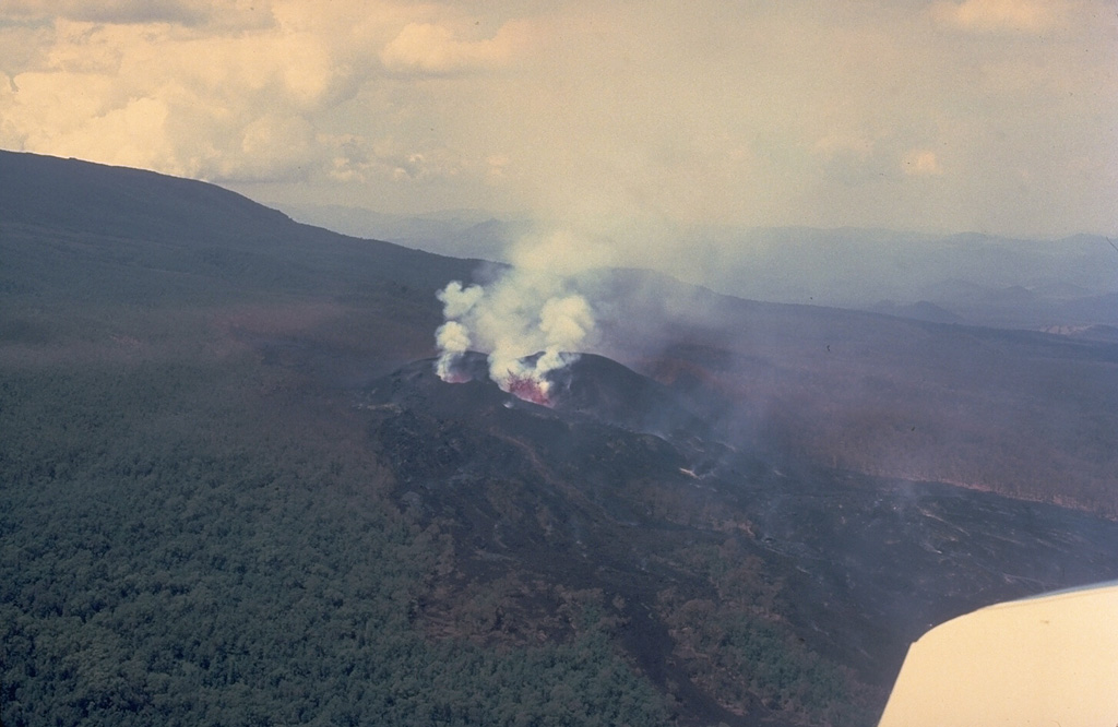
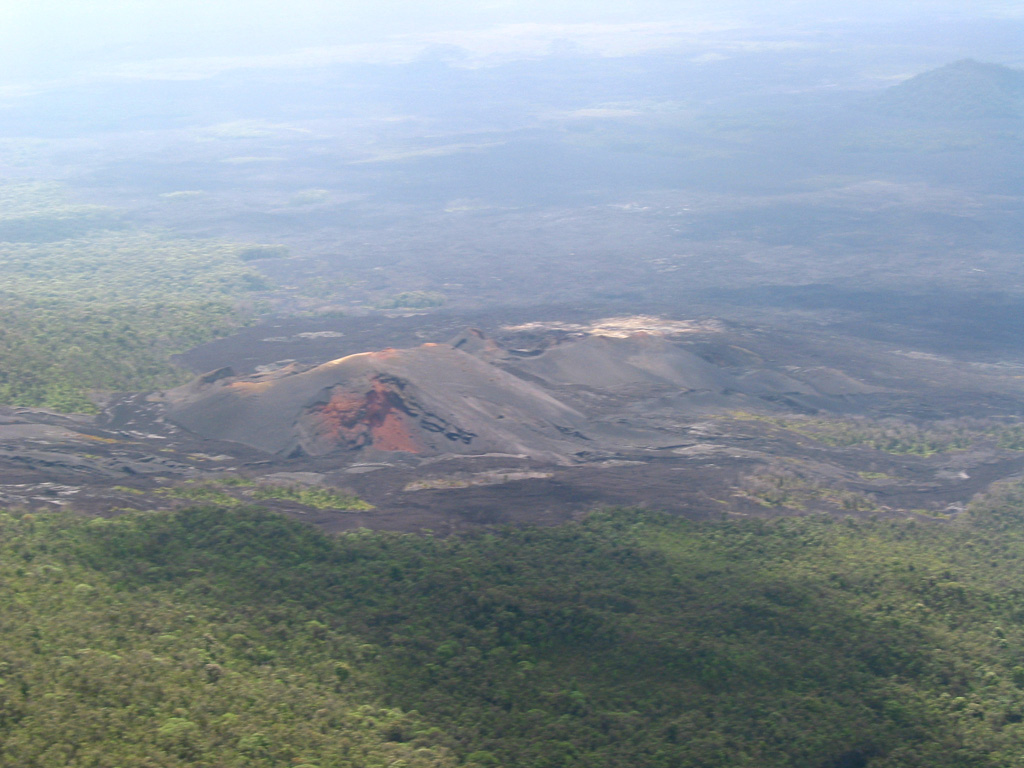
 An aerial view of the SE flank of Nyamuragira shows scoria cones that may have formed during an eruption in 2000. The eruption began the morning of 27 January from a fissure on the SE flank near the site of the 1989 eruption, and included explosive activity and lava effusion. Activity diminished by the 31st, but satellite imagery showed thermal anomalies from lava flows on 10 February.
Photo by Simon Carn, 2004 (TOMS Volcanic Emissions Group, University of Maryland, Baltimore County).
 A lava fountain rises above the Kitazungurwa vent on the S flank of Nyamuragira on 1 August 1986. This eruption began on 16 July from a vent 4.5 km from the southern rim of the caldera. It produced lava flows that traveled to the SW to within a few kilometers of Lake Kivu.
Photo courtesy of Henry-Luc Hody, 1986 (Belgian ambassador).
 This combined NASA Landsat and Shuttle Radar Topography Mission image shows Nyamuragira (left) and Nyiragongo (right) volcanoes rising north of Lake Kivu in the East African Rift Valley. Red areas on Nyiragongo mark the locations of January 2002 flank-vent lava flows, some of which descended through the city of Goma into Lake Kivu. Historical lavas descend from Nyamuragira shield volcano, some of which also reached the lake. Both volcanoes are truncated by small calderas.
NASA Landsat and SRTM image, 2002.
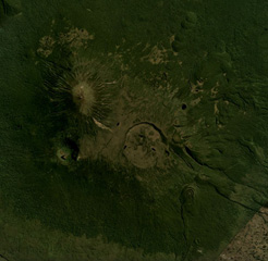 This June 2018 Planet Labs satellite image mosaic (N at the top) shows Karisimbi volcano of the Virunga volcanic field in Rwanda. The 1.5-km-wide Caldera Branca is seen near the center, with the summit to the NW and Mutango crater south of that. Extending SE of the caldera is a lava flow field with individual flows reaching 12 km in length.
Satellite image courtesy of Planet Labs Inc., 2018 (https://www.planet.com/).
 Mikeno volcano (center) and Karisimbi volcano (right) are seen here from the E on the flanks of Nyamuragira volcano. Mikeno is an eroded Pleistocene volcano; Karisimbi is younger. The 2-km-wide Branca caldera is located SE of the summit of Karisimbi and is filled by viscous lava flows and has two craters. More than 100 parasitic cones extend along a NNE-SSW zone to the shores of Lake Kivu.
Photo by Henry-Luc Hody, 1989.
 This February 1980 photo shows the wall of a pit crater within the summit caldera of Nyamuragira volcano. The rim of the 2 x 2.3 km caldera appears in the distance. Many changes to the morphology of the caldera floor have occurred as a result of the frequent historical eruptions of Nyamuragira since the mid-19th century.
Copyrighted photo by Katia and Maurice Krafft, 1980.
This is a compilation of DR Congo volcano information sources, such as official monitoring or other government agencies.
| Volcano Observatories | |
|---|---|
| Goma Volcano Observatory (GVO) | |
| Virunga Volcanoes | |
| Virunga Volcanoes Supersite | |
| Additional Information Sources | |
|---|---|
| Virunga National Park | |
| Volcanic Ash Advisory Center | |
|---|---|
| Toulouse Volcanic Ash Advisory Center (VAAC) Notices and Archive | |